Mecapaca
by Lawrence Rubey and A. Bennett Hennessey
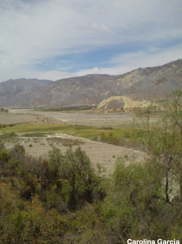
 The surrounding areas of La Paz are justly famous for limited but unusual birdlife of the puna grasslands, the waterbirds of Lake Titicaca and, not least, the diversity of species in the sub-tropical Yungas along the Coroico and Chulumani Roads. Yet La Paz also has an example of the dry valle habitat (or arid, inter-Andean valley) more reminiscent of the Cochabamba area than La Paz. Mecapaca is a prime example of this habitat that also includes farmlands and wetlands. About 28 kilometers from the center of the city of La Paz, the altitude at Mecapaca ranges from 2800 to 2950 meters. For the birder looking for a morning escape or an easy day trip within reach of La Paz, Mecapaca is an ideal destination. Over 60 species have been seen near Mecapaca. By Amazonian lowlands standards this is a small list. But since there are only 130 species or so regular on the Bolivian Altiplano, it is rich for such a small area. Several species reach the limit of their altitudinal range at Mecapaca and other species that are somewhat harder to see elsewhere are easily seen here (i.e. Brown-backed Mockingbird, Red-tailed Comet, and White-tipped Plantcutter). Mecapaca also boasts three endemics: Bolivian Warbling-Finch, Bolivian Earthcreeper, and Bolivian Spinetail (rare). The surrounding areas of La Paz are justly famous for limited but unusual birdlife of the puna grasslands, the waterbirds of Lake Titicaca and, not least, the diversity of species in the sub-tropical Yungas along the Coroico and Chulumani Roads. Yet La Paz also has an example of the dry valle habitat (or arid, inter-Andean valley) more reminiscent of the Cochabamba area than La Paz. Mecapaca is a prime example of this habitat that also includes farmlands and wetlands. About 28 kilometers from the center of the city of La Paz, the altitude at Mecapaca ranges from 2800 to 2950 meters. For the birder looking for a morning escape or an easy day trip within reach of La Paz, Mecapaca is an ideal destination. Over 60 species have been seen near Mecapaca. By Amazonian lowlands standards this is a small list. But since there are only 130 species or so regular on the Bolivian Altiplano, it is rich for such a small area. Several species reach the limit of their altitudinal range at Mecapaca and other species that are somewhat harder to see elsewhere are easily seen here (i.e. Brown-backed Mockingbird, Red-tailed Comet, and White-tipped Plantcutter). Mecapaca also boasts three endemics: Bolivian Warbling-Finch, Bolivian Earthcreeper, and Bolivian Spinetail (rare).
Mecapaca is best birded in the morning, especially on sunny, summer days when bird activity seems to slow down by late morning. Yet late afternoons can also be productive. Assuming an early morning arrival at the small plaza in the village of Mecapaca, a good strategy is to head down hill towards the cultivated and fallow fields and the river. There are several dirt roads and smaller trails. Any taller trees and bushes that border the fields are worth scanning for Cinerous Conebill, Blue-and-yellow Tanager, White-bellied Tyrannulet, and Brown-capped Tit-Spinetail. Listen for Grey-hooded Parakeets that often roost in tree borders in large numbers. Aplomado Falcon is even possible in the introduced eucalyptus. Slowly work your way downriver through the cultivated areas. In the open areas a few hundred meters from the river, is a small wetland and reedbed that is worth checking for Plumbeous Rail and possibly Puna Snipe.
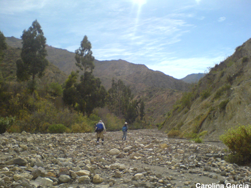
 As the river plain narrows and becomes more arid, turn left and head up the conspicuous arid canyon that comes down from the mountains. Join a small dirt road where a left turn will bring you back to town (completing the loop). A more interesting variation can be had by making a right-turn at the small dirt road and following the road a kilometer or so to a dry valley with cactus and thorn bushes (see GPS coordinates). Here, if the sun has not gotten to high, the western slopes should be in shade and bird activity will still be high. Bolivian Warbling-Finch may be spotted feeding in the thorn bushes. Rufous-sided Warbling Finch is also fairly common, so check any Warbling-Finches carefully. Red-tailed Comet is relatively easy to spot near flowering plants. Giant Hummingbird and D'Orbigny's Chat-Tyrant can be anywhere. White-winged Black-Tyrant (austral migrant), Brown-backed Mockingbird and White-tipped Plantcutter all perch conspicuously and are hard to miss. This circuit can be done in two to four hours depending on how many times you stop to raise your binoculars. As the river plain narrows and becomes more arid, turn left and head up the conspicuous arid canyon that comes down from the mountains. Join a small dirt road where a left turn will bring you back to town (completing the loop). A more interesting variation can be had by making a right-turn at the small dirt road and following the road a kilometer or so to a dry valley with cactus and thorn bushes (see GPS coordinates). Here, if the sun has not gotten to high, the western slopes should be in shade and bird activity will still be high. Bolivian Warbling-Finch may be spotted feeding in the thorn bushes. Rufous-sided Warbling Finch is also fairly common, so check any Warbling-Finches carefully. Red-tailed Comet is relatively easy to spot near flowering plants. Giant Hummingbird and D'Orbigny's Chat-Tyrant can be anywhere. White-winged Black-Tyrant (austral migrant), Brown-backed Mockingbird and White-tipped Plantcutter all perch conspicuously and are hard to miss. This circuit can be done in two to four hours depending on how many times you stop to raise your binoculars.
Be sure not to trespass on any fields that have crops. It is usually fairly easy to avoid trampling on crops by walking along the mounds built up along the edges of the fields. These mounds have usually seen a fair amount of foot traffic.
Logistics: One of the great attractions of Mecapaca is that it is only 45 minutes from La Paz city center and even closer to the Zona Sur (the southern suburbs of La Paz). Moreover, it is easily reached by taxi or one of the regular minibuses. For 20 USD you can hire a taxi for the morning or afternoon, which can take you to Mecapaca, wait for you at the main plaza and return you to La Paz after. This will avoid the hassle of trying to find a return taxi in this small town. Make the agreement that you will pay in full at the end of the trip in La Paz. Minibuses (number 253--look for the "Mecapaca" sign on the dashboard) leave for Mecapaca regularly from Plaza Humbolt, a small plaza on the right as you cross into the Zona Sur. Mecapaca is the "end of the line" so transportation back is not a problem. If you have your vehicle re-set odometer to 0.0 at Plaza Humbolt. From Plaza Humbolt, follow Calle 8 to the stoplight and turn right onto the Costanera highway (heading back toward downtown). Within 100 meters, enter a small traffic circle and bear to the left (0.5 kms). The Rio La Paz will now be on your right. (If you have trouble, ask anyone for the road to Mallasa or to the zoo). At 2.4 km, cross a small bridge over the Rio La Paz, and begin a steep ascent. At 4.2 km, pass the Valle de la Luna (Valley of the Moon), a popular tourist destination with strange eroded sandstone formations. However, any birds found here will also be found at Mecapaca. At 10.1 km, a long bridge re-crosses the Rio Paz and the road begins to ascend again. Enter the town of Valencia (18.2 km) and finally, at 20 km, the town of Mecapaca (see GPS coordinates). Either park in the small main plaza in Mecapaca or down by the river. From the plaza, the road continues south another couple kilometers or so until it dead-ends at a dilapidated pig farm in a dry valley (see GPS coordinates). This dry valley can be excellent early in the morning.
A couple spots on the way might be worth a quick stop. Parque Bartolina Sisa Aranjuez, a small urban amusement park, fronts the Choqueyapu River and offers a chance at seeing Red-tailed Comet if there are blooming flowers. Only worth a stop (and a very short one at that) if it is early morning. Also before arriving at Mecapaca (10 km from Plaza Humbolt), a large bridge crosses over the Rio La Paz before climbing uphill on the paved road. This area, called "Ananta," has some indigenous vegetation (disappearing fast!) and is worth exploring.
GPS reading at Mecapaca plaza: S 16 40.101 W 68 00.998
GPS reading at dry valley near Mecapaca: S 16 39.919 W 68 00
|

